The cyclone, named Biparjoy, is expected to make landfall on Thursday afternoon between Mandvi in Gujarat and Karachi in Pakistan with a maximum sustained wind speed of 125-135kmph (78-84mph), gusting up to 150kmph (93mph), the India Meteorological Department (IMD) said on Monday.
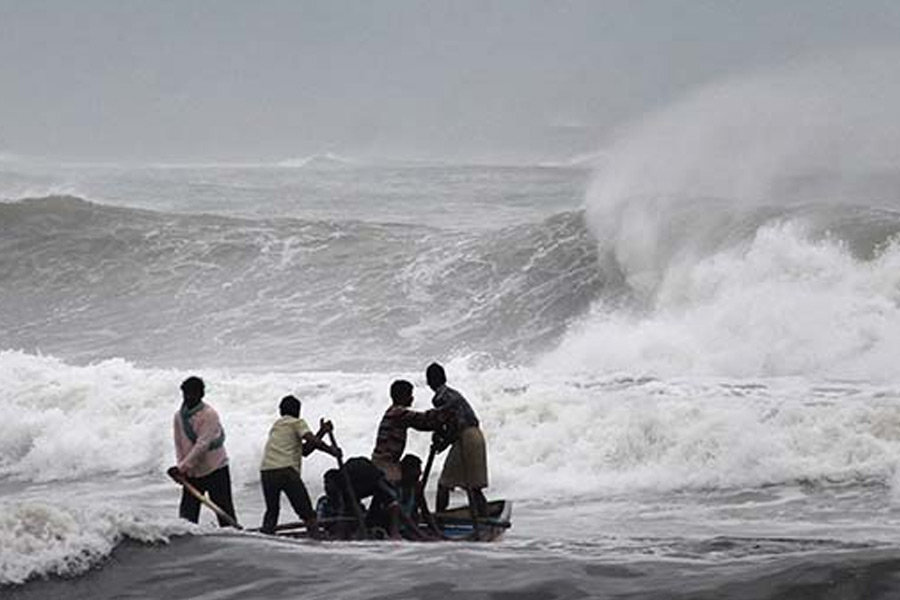
The IMD has advised fishing communities to halt operations and the evacuation of people from the coastal areas of Saurashtra and Kutch regions of Gujarat.
Two of India’s biggest ports – Mundra and Kandla – are in the Gulf of Kutch, while the Jamnagar refinery, the world’s biggest oil refinery complex owned by Reliance Industries, is based in the Saurashtra region.
The Gujarat Pipavav Port Limited, in a stock exchange filing on Monday, said operations at its Pipavav Port had been suspended since late Saturday evening due to “prevailing severe weather conditions”.
Seven teams of India’s National Disaster Response Force and 12 teams of State Disaster Response Force have been deployed in the districts likely to be affected by the cyclone, Gujarat Chief Minister Bhupendra Patel said in a tweet.
Nearly a dozen districts in coastal Gujarat would be affected by heavy rainfall and gusting winds, although some of the districts are sparsely populated, which would limit the damage, said a weather official who declined to be named.
In neighbouring Pakistan, the National Disaster Management Authority (NDMA) said instructions were being given for precautionary measures in southern and southeastern parts of the country that are likely to be affected.
“Its [the cyclone’s] evolving impact will only be certain with further development of the situation,” the authority said in a statement. A top official of the NDMA said that the authorities have started moving people from the low-lying coastal areas in Sindh to temporary shelters in government schools and offices as the cyclone is expected to make its landfall in Keti Bandar and its adjoining areas.
Keti Bandar is one of the oldest ports in Sindh. Karachi’s Seaview Road was blocked for traffic on Monday to prevent people from heading out into the open sea as the Pakistan Meteorological Department (PMD) said Biparjoy was around 600km away from the coastal city.
Section 144 has been imposed in Karachi, and entry to the port city’s beaches is banned.
The residents of the Defence Housing Authority (DHA), one of the upscale areas in Karachi, have been advised to take precautionary measures as Biparjoy moves closer to the metropolis.
“We are expecting the high-intensity winds, heavy rainfalls, thunderstorms and high tides to damage vulnerable structures, so we have started taking precautions and are evacuating the people at least 10 kilometres away from coastal areas,” Jahanzaib Khan, the NDMA official, said.
The NDMA has also issued directions that all high-rise buildings and mobile towers in Karachi must be lit up by beacon lights and big advertisement boards on poles and buildings should either be strengthened or removed altogether if they pose a threat to passing traffic and the people.
In another precautionary measure, the Pakistan Civil Aviation Authority’s airside department has also alerted the relevant officials to ensure the safety of lightweight aircraft and other electrical equipment by taking precautionary measures such as mooring of parked light aircraft or re-parking to a safer place.
The precautions came as the PMD issued a fresh advisory which said the cyclone had “moved further northward during the last 12 hours”.
The Met department said the system was “most likely to track further northward until June 14 morning”.
It added that the cyclone would then recurve northeastward and cross between Keti Bandar (southeast Sindh) and the Indian Gujarat coast on June 15 as a “very severe cyclonic storm”.
The PMD said the cyclone’s maximum sustained surface winds were 160-180km per hour, while gusts as high as 200km/h were around the system centre. Sea conditions were “phenomenal around the system centre with maximum wave height 35-40 feet”, it added.
“The favourable environmental conditions … are supporting the system to maintain its intensity,” the PMD said. The department added that its cyclone warning centre in Karachi was continuously monitoring the system and would issue updates accordingly.
In its alert, the PMD cited the system’s approach towards the southeast Sindh coast and warned citizens that “widespread wind-dust/thunderstorm rain with some very heavy/extremely heavy falls accompanied with squally winds of 80-100km/hour” were likely in Thatta, Sujawal, Badin, Tharparker and Umerkot districts from June 13-17.
It further said that “dust/thunderstorm-rain with few heavy falls and accompanied with squally winds of 60-80km/h” were likely in Karachi, Hyderabad, Tando Muhammad Khan, Tando Allayar, Shaheed Benazirabad and Sanghar districts from June 14 to 16.
“Squally (high-intensity) winds may cause damage to loose & vulnerable structures, including solar panels, etc.,” the department said.
A storm surge of 3-3.5 metres was expected when the cyclone made landfall which could inundate low-lying settlements, it highlighted.
The PMD advised fishermen not to venture out into the open sea “till the system is over by June 17 as the Arabian Sea conditions may get very rough/high accompanied with high tides along the coast”.
Talking to the Dawn newspaper, Met Office spokesperson Sardar Sarfaraz said the maximum wave height could go up to 12ft when the cyclone hit Pakistan’s coastline.
Sherry Rehman, Minister for Climate Change and Environment, said that the NDMA, with its provincial units, would coordinate with Pakistan Navy, Pakistan Maritime Security Authority, and Pakistan Coast Guards in rescue efforts and ensure the safety of people.
“Biparjoy is unpredictable yet categorised as high intensity. Panic is counterproductive, but caution and planning are better than being caught unawares,” the minister said.
The NDMA has also taken precautionary measures because of the threat of the Cyclone to coastal areas of Balochistan, and a complete ban on going towards the coastal area in Gwadar has been imposed, and an emergency has been declared in hospitals.
The Gwadar administration has also set up a control room to monitor the situation and deal with emergencies.
The strongest cyclone to hit Pakistan was the 1999 Keti Bandar, a category 3 storm on the Saffir–Simpson scale. It resulted in the deaths of 6,200 people in Sindh’s impoverished Thatta district, where Biparjoy is also likely to hit.
Pakistan is still to recover from losses caused by unprecedented floods last year.
Over 1,700 people were killed, and more than 33 million were affected due to massive floods.
In India’s Gujarat state, a 1998 cyclone killed at least 4,000 people and caused damage estimated at hundreds of millions of dollars.
Biparjoy delayed the onset of the annual monsoon over the southern state of Kerala, but now conditions are favourable for the progress of much-needed rains in some more parts of Maharashtra, Karnataka, Andhra Pradesh and Tamil Nadu states, the weather office said.
